

Flooding hazards in Selwyn
As part of the Selwyn District Plan Review, the Council has identified areas that may be at risk from flooding and developed proposed rules for how to manage that risk.
While the current District Plan manages a risk from a 50-year flood event, in the new Proposed District Plan we are required to identify and manage areas at risk from more extreme rainstorms and taking into account climate change effects over the next 100 years.
On this website you can find all relevant information on identified flood hazard in Selwyn and how we propose to manage it in the newContinue reading
As part of the Selwyn District Plan Review, the Council has identified areas that may be at risk from flooding and developed proposed rules for how to manage that risk.
While the current District Plan manages a risk from a 50-year flood event, in the new Proposed District Plan we are required to identify and manage areas at risk from more extreme rainstorms and taking into account climate change effects over the next 100 years.
On this website you can find all relevant information on identified flood hazard in Selwyn and how we propose to manage it in the new District Plan.
Background
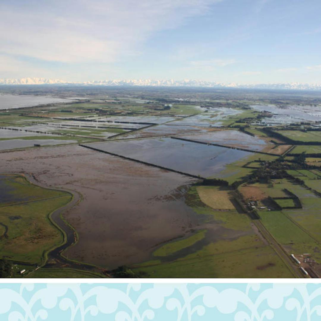
Floods are usually caused by continuous heavy rain or thunderstorms that the land cannot absorb quickly enough. This can then cause ponding, or rivers and streams to overflow. Our district is more prone to flooding, given our extensive low-lying plains and many braided rivers.
Selwyn is bounded by two major rivers – the Waimakariri to the north and the Rakaia to the south. The district is also bisected by the Selwyn River which is fed by the Hororata, Hawkins and Waianiwaniwa Rivers.
When looking at flood hazards outside coastal areas as part of the District Plan Review work, the Selwyn District Council considered two types of flooding:
- surface flooding, ie when the land can’t absorb rainfall and excess water runs off or ponds, and
- overflows from the Selwyn River.
Have a question about flooding hazards in Selwyn? We would like to hear from you.
-
Share When is this proposed new flood risk management going to be implemented? How does one find the land that is subject to this proposed district plan? on Facebook Share When is this proposed new flood risk management going to be implemented? How does one find the land that is subject to this proposed district plan? on X (formerly Twitter) Share When is this proposed new flood risk management going to be implemented? How does one find the land that is subject to this proposed district plan? on Linkedin Email When is this proposed new flood risk management going to be implemented? How does one find the land that is subject to this proposed district plan? link
When is this proposed new flood risk management going to be implemented? How does one find the land that is subject to this proposed district plan?
Hadley Wright asked about 6 years agoHi Hadley,
The proposed changes to how flood risk in the Selwyn District is managed are part of the Proposed District Plan, which needs to be first notified for public consultation (expected later this year). Any new proposed rules will come into effect only once the new Proposed District Plan is fully in place, which is expected to be in 2022. Until then, current rules for building and resource consents apply.
As for how to find out if land on your property may be affected by flooding during some extreme weather events, check out this website which has a flooding map that allows you to search for your property by using the search function at the top right hand corner on the map. On the same website you can also find this information sheet that gives a bit more information about the map. If you need any further help please give us a call on 0800 SELWYN (735 996).
Kind regards,
Selwyn District Plan Review Team
-
Share I have a few questions about the surface flooding model from DHI. 1) What is the uncertainty in the modelled flood depth? Related to this, given the uncertainty in some of the model inputs the centimetre precision in the flooding map seems unrealistic. 2) There has been limited validation of the model. Is the council planning to carry out further calibration/validation as/when storm events occur? 3) The LiDAR data used in the modelling for my area was collected before my property was built. When will the model next be updated to include the latest LiDAR information and how will my property be treated in the interim? on Facebook Share I have a few questions about the surface flooding model from DHI. 1) What is the uncertainty in the modelled flood depth? Related to this, given the uncertainty in some of the model inputs the centimetre precision in the flooding map seems unrealistic. 2) There has been limited validation of the model. Is the council planning to carry out further calibration/validation as/when storm events occur? 3) The LiDAR data used in the modelling for my area was collected before my property was built. When will the model next be updated to include the latest LiDAR information and how will my property be treated in the interim? on X (formerly Twitter) Share I have a few questions about the surface flooding model from DHI. 1) What is the uncertainty in the modelled flood depth? Related to this, given the uncertainty in some of the model inputs the centimetre precision in the flooding map seems unrealistic. 2) There has been limited validation of the model. Is the council planning to carry out further calibration/validation as/when storm events occur? 3) The LiDAR data used in the modelling for my area was collected before my property was built. When will the model next be updated to include the latest LiDAR information and how will my property be treated in the interim? on Linkedin Email I have a few questions about the surface flooding model from DHI. 1) What is the uncertainty in the modelled flood depth? Related to this, given the uncertainty in some of the model inputs the centimetre precision in the flooding map seems unrealistic. 2) There has been limited validation of the model. Is the council planning to carry out further calibration/validation as/when storm events occur? 3) The LiDAR data used in the modelling for my area was collected before my property was built. When will the model next be updated to include the latest LiDAR information and how will my property be treated in the interim? link
I have a few questions about the surface flooding model from DHI. 1) What is the uncertainty in the modelled flood depth? Related to this, given the uncertainty in some of the model inputs the centimetre precision in the flooding map seems unrealistic. 2) There has been limited validation of the model. Is the council planning to carry out further calibration/validation as/when storm events occur? 3) The LiDAR data used in the modelling for my area was collected before my property was built. When will the model next be updated to include the latest LiDAR information and how will my property be treated in the interim?
Sam asked about 6 years agoHi Sam,
The DHI technical report, which is available here, sets out the limitations of the flooding model. The model design is such that it is not possible to put a +- figure on the results; they are what they are, for the flooding scenarios that were modelled.
Updating and re-running the model is a time-consuming and expensive process. As such, the Council is unlikely to update the model in the absence of significant new information or legislative requirements. In general, this means that natural hazards, including flooding, are reassessed as part of the regular district plan review cycle, which is legally required to be every ten years or so.
The valid concerns raised in all your questions are why the Council is not proposing to use the flood modelling results as the sole source of information for managing flood hazards on a site (such as, for example, determining an appropriate minimum floor height for a new house). Rather, proposed development in an identified flood risk area would trigger the need for a site-specific expert assessment. In this way factors such as new flood information and changed ground levels since the LiDAR survey for that location was last undertaken, can be taken into account.
We’d be happy to talk to you if you have any further questions. Please give us a call on 0800 SELWYN (735 996).
Thanks,
Selwyn District Plan Review Team
-
Share What is the flood risk to Springfield in the new plan. on Facebook Share What is the flood risk to Springfield in the new plan. on X (formerly Twitter) Share What is the flood risk to Springfield in the new plan. on Linkedin Email What is the flood risk to Springfield in the new plan. link
What is the flood risk to Springfield in the new plan.
Harley asked over 6 years agoThank you for your query. If you are interested in a particular area, we suggest you use the search function at the top right hand corner of the flooding map. You can search by property address or town name. For Springfield, search ‘Springfield, NZL’.
Please note that any proposed rules will come into effect once the new District Plan is fully in place, which is expected to be in 2022. Until then, current rules for building and resource consents continue to apply.
Thanks,
Selwyn District Plan Review Team
-
Share To whom it may concern. Yesterday to my surprise I received a letter in the mail dated 13 March 2020 titled "District Plan Review: Managing Flood Risk in the District". This is related specifically to Surface flooding and overflows at the Selwyn River. For clarity I live in the West Melton Township. Which is some 20+Km North East of the Selwyn River. I have contacted several neighbours who also received the same letter (as my initial though was I randomly received this letter by mistake?). I have also reviewed the "Selwyn River/Waikirikiri floodplain investigation Report No. R19/41" from Michelle Wild dated September 2019 which is referenced as the most relevant report. Although only a quick review, I can't see how this references West Melton township at all? However, this may not be the case. Therefore, I ask that you please clarify that this is actually somehow affecting my property as it looks like a complete error that West Melton as a township is being brought into this process. I appreciate your response on this matter. on Facebook Share To whom it may concern. Yesterday to my surprise I received a letter in the mail dated 13 March 2020 titled "District Plan Review: Managing Flood Risk in the District". This is related specifically to Surface flooding and overflows at the Selwyn River. For clarity I live in the West Melton Township. Which is some 20+Km North East of the Selwyn River. I have contacted several neighbours who also received the same letter (as my initial though was I randomly received this letter by mistake?). I have also reviewed the "Selwyn River/Waikirikiri floodplain investigation Report No. R19/41" from Michelle Wild dated September 2019 which is referenced as the most relevant report. Although only a quick review, I can't see how this references West Melton township at all? However, this may not be the case. Therefore, I ask that you please clarify that this is actually somehow affecting my property as it looks like a complete error that West Melton as a township is being brought into this process. I appreciate your response on this matter. on X (formerly Twitter) Share To whom it may concern. Yesterday to my surprise I received a letter in the mail dated 13 March 2020 titled "District Plan Review: Managing Flood Risk in the District". This is related specifically to Surface flooding and overflows at the Selwyn River. For clarity I live in the West Melton Township. Which is some 20+Km North East of the Selwyn River. I have contacted several neighbours who also received the same letter (as my initial though was I randomly received this letter by mistake?). I have also reviewed the "Selwyn River/Waikirikiri floodplain investigation Report No. R19/41" from Michelle Wild dated September 2019 which is referenced as the most relevant report. Although only a quick review, I can't see how this references West Melton township at all? However, this may not be the case. Therefore, I ask that you please clarify that this is actually somehow affecting my property as it looks like a complete error that West Melton as a township is being brought into this process. I appreciate your response on this matter. on Linkedin Email To whom it may concern. Yesterday to my surprise I received a letter in the mail dated 13 March 2020 titled "District Plan Review: Managing Flood Risk in the District". This is related specifically to Surface flooding and overflows at the Selwyn River. For clarity I live in the West Melton Township. Which is some 20+Km North East of the Selwyn River. I have contacted several neighbours who also received the same letter (as my initial though was I randomly received this letter by mistake?). I have also reviewed the "Selwyn River/Waikirikiri floodplain investigation Report No. R19/41" from Michelle Wild dated September 2019 which is referenced as the most relevant report. Although only a quick review, I can't see how this references West Melton township at all? However, this may not be the case. Therefore, I ask that you please clarify that this is actually somehow affecting my property as it looks like a complete error that West Melton as a township is being brought into this process. I appreciate your response on this matter. link
To whom it may concern. Yesterday to my surprise I received a letter in the mail dated 13 March 2020 titled "District Plan Review: Managing Flood Risk in the District". This is related specifically to Surface flooding and overflows at the Selwyn River. For clarity I live in the West Melton Township. Which is some 20+Km North East of the Selwyn River. I have contacted several neighbours who also received the same letter (as my initial though was I randomly received this letter by mistake?). I have also reviewed the "Selwyn River/Waikirikiri floodplain investigation Report No. R19/41" from Michelle Wild dated September 2019 which is referenced as the most relevant report. Although only a quick review, I can't see how this references West Melton township at all? However, this may not be the case. Therefore, I ask that you please clarify that this is actually somehow affecting my property as it looks like a complete error that West Melton as a township is being brought into this process. I appreciate your response on this matter.
Ryan asked over 6 years agoHi,
As part of the District Plan Review we’ve had to assess the whole Selwyn District and identify areas at risk from flooding during a 200-year flood event. The investigations considered two types of flooding: surface flooding and Selwyn River overflow. Areas of West Melton could be affected by surface flooding, ie when the land can’t absorb rainfall and excess water runs off or ponds. The technical report relevant to West Melton is by DHI Water and Environment Ltd: Regional Policy Statement Modelling for SDC – District Plan.
Selwyn District Plan Review Team
-
Share Hi, Just wondering whether recreational buildings and farm buildings and accommodation for the farm is still able to get resource consent within the new overlay?? on Facebook Share Hi, Just wondering whether recreational buildings and farm buildings and accommodation for the farm is still able to get resource consent within the new overlay?? on X (formerly Twitter) Share Hi, Just wondering whether recreational buildings and farm buildings and accommodation for the farm is still able to get resource consent within the new overlay?? on Linkedin Email Hi, Just wondering whether recreational buildings and farm buildings and accommodation for the farm is still able to get resource consent within the new overlay?? link
Hi, Just wondering whether recreational buildings and farm buildings and accommodation for the farm is still able to get resource consent within the new overlay??
Jo asked about 6 years agoHi Jo,
We're currently still finalising the proposed rules for formal public consultation once the Proposed District Plan is notified. As the provisions stand at the moment, where a new house or other principal building complies with the identified minimum floor height for the building site (proposed 300mm above the 200-year flood level), then a resource consent would not be required – just the usual building consent process would apply. A resource consent would only be required if such a building proposes not to comply with the identified minimum floor height.
New accessory buildings such as residential garages, farm implement sheds or hay sheds would not need to comply with an identified minimum floor height.
Keep an eye on this website for when the Proposed District Plan is notified for the formal public consultation. Please note that any new rules will get into effect only once the new plan is fully operational. This is expected to be at least two years away from now.
Kind regards,
Selwyyn District Plan Review Team
-
Share Hello, much like Ryan's question down below but I live in Rolleston. Where is the link to the reference material in relation to the flood risk for my property. I also note that public drop-in session was on 30 March which has been during level 4 lock down. Will there be another one at a future date? on Facebook Share Hello, much like Ryan's question down below but I live in Rolleston. Where is the link to the reference material in relation to the flood risk for my property. I also note that public drop-in session was on 30 March which has been during level 4 lock down. Will there be another one at a future date? on X (formerly Twitter) Share Hello, much like Ryan's question down below but I live in Rolleston. Where is the link to the reference material in relation to the flood risk for my property. I also note that public drop-in session was on 30 March which has been during level 4 lock down. Will there be another one at a future date? on Linkedin Email Hello, much like Ryan's question down below but I live in Rolleston. Where is the link to the reference material in relation to the flood risk for my property. I also note that public drop-in session was on 30 March which has been during level 4 lock down. Will there be another one at a future date? link
Hello, much like Ryan's question down below but I live in Rolleston. Where is the link to the reference material in relation to the flood risk for my property. I also note that public drop-in session was on 30 March which has been during level 4 lock down. Will there be another one at a future date?
Jamie T asked about 6 years agoHi Jamie,
The flood modelling has identified that Rolleston, like West Melton, could be affected by surface flooding during a 200-year flood event. All the details of the model can be found in the technical report by DHI Water and Environment Ltd: Regional Policy Statement Modelling for SDC – District Plan. This technical report is also available under the heading ‘Supporting Information’ .
As for the planned public-drop sessions you’re right we had to cancel them due to COVID-19 pandemic. At this stage we don’t have any plans for rescheduling them. However, if you have any questions that you would like to discuss with us you can still call us on 0800 SELWYN (735 996) or email contactus@selwyn.govt.nz.
Thanks,
Selwyn District Plan Review Team
-
Share Q1. If a property e.g. 1 acre has a dwelling site which the model shows is not predicted to be impacted by a 200 year or 500 year event, and has say, 5 metres clear on all sides why couldn't a 'no flood' designation be given for the building site and a 'flood' designation be given for the non-building site area? Q2. If there is a safe area (i.e. non -flood area) around the current building site e.g. 5 metres, why then couldn't an extension be permitted in the safe area without having to complete a survey to get approval. Particularly, if any extension still maintained a 5 metre distance from the nearest flood point? This is a compliance cost issue and perhaps also an insurance issue where a property owner can be unfairly prejudiced by a label which may affect part of the property but not the part that really counts. Can some accommodation in this area be given in terms of the policy development? Q3 how does the Council propose to update the model to allow for changes in expectations or flood mitigation strategies implemented by the Council? on Facebook Share Q1. If a property e.g. 1 acre has a dwelling site which the model shows is not predicted to be impacted by a 200 year or 500 year event, and has say, 5 metres clear on all sides why couldn't a 'no flood' designation be given for the building site and a 'flood' designation be given for the non-building site area? Q2. If there is a safe area (i.e. non -flood area) around the current building site e.g. 5 metres, why then couldn't an extension be permitted in the safe area without having to complete a survey to get approval. Particularly, if any extension still maintained a 5 metre distance from the nearest flood point? This is a compliance cost issue and perhaps also an insurance issue where a property owner can be unfairly prejudiced by a label which may affect part of the property but not the part that really counts. Can some accommodation in this area be given in terms of the policy development? Q3 how does the Council propose to update the model to allow for changes in expectations or flood mitigation strategies implemented by the Council? on X (formerly Twitter) Share Q1. If a property e.g. 1 acre has a dwelling site which the model shows is not predicted to be impacted by a 200 year or 500 year event, and has say, 5 metres clear on all sides why couldn't a 'no flood' designation be given for the building site and a 'flood' designation be given for the non-building site area? Q2. If there is a safe area (i.e. non -flood area) around the current building site e.g. 5 metres, why then couldn't an extension be permitted in the safe area without having to complete a survey to get approval. Particularly, if any extension still maintained a 5 metre distance from the nearest flood point? This is a compliance cost issue and perhaps also an insurance issue where a property owner can be unfairly prejudiced by a label which may affect part of the property but not the part that really counts. Can some accommodation in this area be given in terms of the policy development? Q3 how does the Council propose to update the model to allow for changes in expectations or flood mitigation strategies implemented by the Council? on Linkedin Email Q1. If a property e.g. 1 acre has a dwelling site which the model shows is not predicted to be impacted by a 200 year or 500 year event, and has say, 5 metres clear on all sides why couldn't a 'no flood' designation be given for the building site and a 'flood' designation be given for the non-building site area? Q2. If there is a safe area (i.e. non -flood area) around the current building site e.g. 5 metres, why then couldn't an extension be permitted in the safe area without having to complete a survey to get approval. Particularly, if any extension still maintained a 5 metre distance from the nearest flood point? This is a compliance cost issue and perhaps also an insurance issue where a property owner can be unfairly prejudiced by a label which may affect part of the property but not the part that really counts. Can some accommodation in this area be given in terms of the policy development? Q3 how does the Council propose to update the model to allow for changes in expectations or flood mitigation strategies implemented by the Council? link
Q1. If a property e.g. 1 acre has a dwelling site which the model shows is not predicted to be impacted by a 200 year or 500 year event, and has say, 5 metres clear on all sides why couldn't a 'no flood' designation be given for the building site and a 'flood' designation be given for the non-building site area? Q2. If there is a safe area (i.e. non -flood area) around the current building site e.g. 5 metres, why then couldn't an extension be permitted in the safe area without having to complete a survey to get approval. Particularly, if any extension still maintained a 5 metre distance from the nearest flood point? This is a compliance cost issue and perhaps also an insurance issue where a property owner can be unfairly prejudiced by a label which may affect part of the property but not the part that really counts. Can some accommodation in this area be given in terms of the policy development? Q3 how does the Council propose to update the model to allow for changes in expectations or flood mitigation strategies implemented by the Council?
Lieuwe Doubleday asked about 6 years agoHi Lieuwe,
Thanks for your query. Here are our responses to your particular questions. But please if you need further clarification, give us a call on
0800 SELWYN (735 996).
Q1. That is what is currently being proposed. If the proposed position of a building is outside the area where the model has identified a flood depth of 5cm or more in a 200-year flood event, then flood management provisions such as a minimum floor height would not apply to that building, even if there are other parts of the property that have been identified as being at risk. It is only if you are proposing to undertake activities in an area identified as being at risk that additional provisions would apply. Also note that we are not proposing any changes for areas of land that are predicted to flood during a 500-year flood event.
Q2. Again, that is what is currently being proposed. If the location of any building work is outside the identified flooding risk area, then additional provisions would not be required.
Q3. The significant complexity and costs involved in running flood models mean that it is very difficult to justify re-running them in the absence of robust new information, such as changed regional or national requirements, or significant new information such as new climate change information. In general, these updates are limited to the district plan review process which occurs every ten years.
Kind regards,
Selwyn District Plan Review Team
Selwyn's flooding and coastal hazards map

FAQs about flooding hazards
- How can I find out if my property may be affected by flooding during extreme weather events?
- How do these proposed changes affect me?
- What are the main differences between the current District Plan and the new Proposed District Plan in regards to flooding and coastal hazards?
- What do these proposed changes mean for my current building and/or resource consent application?
- I don’t agree with your mapped area on my property being at risk from flooding as it has never been flooded before. What should I do?
- What’s the LIM note on my property report going to say if I may be at risk from a flooding hazard?
- What do these changes mean for my house insurance?
Supporting information
-
 Detailed factsheet on flooding hazards (3.41 MB) (PDF)
-
Technical report: DHI Water and Environment Ltd report – Regional Policy Statement Modelling for SDC – District Plan
-
Technical report: Selwyn River/Waikirikiri floodplain investigation
-
Factsheet on flooding and coastal hazards in Selwyn (2.51 MB) (PDF)